What To Know About Topographic Surveys | Corona, CA

topographic map

According to the Cambridge Dictionary, the topography of a given area refers to “the physical appearance of the natural features of an area of land, especially the shape of its surface.” When the experienced professionals at CalVada conduct a topographic survey, it allows the owner of the plot to understand the existing conditions, contours, elevations, and points of interest within that location. It’s important for new or prospective property owners to have a  well-rounded understanding of the features of their property. More than just property owners, engineers, developers, architects, and telecommunication providers all rely on the information from these surveys to understand how they may proceed with any changes to a property.

Continue reading “What To Know About Topographic Surveys | Corona, CA”

The Environmental Industry Needs Land Survey Services | Corona, CA

In this day and age, it is important that we do everything we can to create a more sustainable way of living on this planet. This being said, when designing or constructing a building, a bridge, a water pipeline or any infrastructure asset, it is important to get a land survey to find out if what you’d like to develop is actually feasible.

A land survey is generally required when designing or constructing structures such as buildings, roads, parking lots, utility corridors, or athletic fields, etc. Why? Because these surveys can give detailed account of horizontal and vertical dimensions and elevations of the structure in question, and also show above ground attributes such as utilities, access roads, parking spaces, fences, etc. More specifically, land survey deliverables for the Environmental Industry include:

  • Geotracker surveys on newly installed groundwater monitoring wells
  • Earth quantity calculations used to determine the amount of contaminated dirt to be removed
  • Topographic surveys for any environmental infrastructure design project
  • Construction staking for any environmental project that is being built from the ground up

To find out more about land surveys, please contact us at (800) CALVADA or visit www.calvada.com.

Calvada proudly serves Corona and all surrounding areas.

There Are Benefits to Hiring Topographical Surveyors | Corona, CA

In the time of buying land or property, you or your agent should be in contact with topographical surveyors in order to educate you about the property territories and lines. From installing the fence to the land survey, surveyors will help you determine the topographic layout to make the correct decisions as a homeowner.

Topographic surveys will provide numerous benefits:

Your soil. Topographical surveyors can make you aware of your flood zone when you are buying a property. This will help you determine with your architect/engineer proper building parameters.       

Construction prep. Before starting construction, make sure you have already consulted a trained architect/engineer who will give you the green light. It’s important to check the soil to see if it is suitable for making a foundation. They will also check the underground water levels. These are all processes that an architect/engineer will go through before giving you their final opinion to begin construction.

Property value. Believe it or not, but topographical surveyors play a crucial role when purchasing or selling property and the reasons are pretty simple – if you are going to invest your hard-earned money, a topographical surveyor who will help you obtain the proper property information so an agent can help you to determine the value of the particular property.

It is fairly obvious that a topographical surveyor’s role in your land purchase/sale is a huge one, and thankfully, you can be secure in your purchases knowing that a professional is on your side. They are not only experts in their fields, but they will provide you with a plethora of benefits when you hire one. If you need a land surveyor for your property, contact Calvada Surveying, Inc.

To find out more about hiring topographical surveyors, please contact us at (800) CALVADA or visit www.calvada.com.

Calvada proudly serves Corona and all surrounding areas.

Topographic Surveys: Is It Worth Developing the Land? | Corona, CA

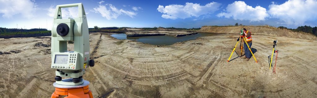
When buying a parcel of land to develop, it is important to know what kind of land you are buying and whether or not it is able to be developed. The solution is a topographic survey, showing the exact location of both human-made and natural features, both vertical and horizontal, in order to determine changes in elevation on a parcel of land.

Most people want to have as much information as possible before beginning a project, and topography is no exception because elevation has a considerable impact on land usability. Finding issues before it’s too late will not only save money but gives an opportunity to plan alternative options when developing the land.

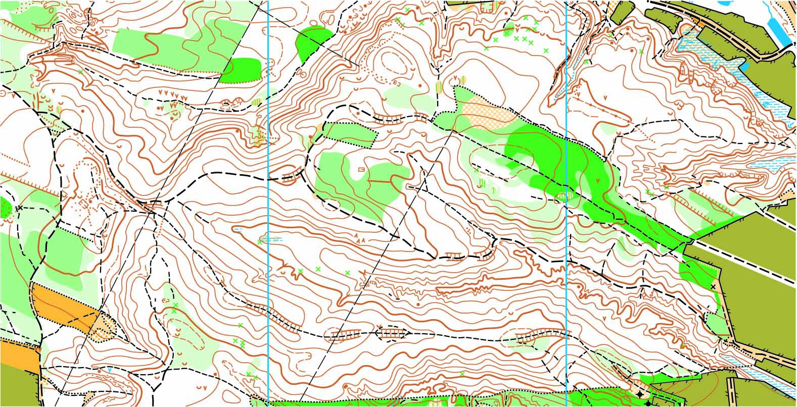
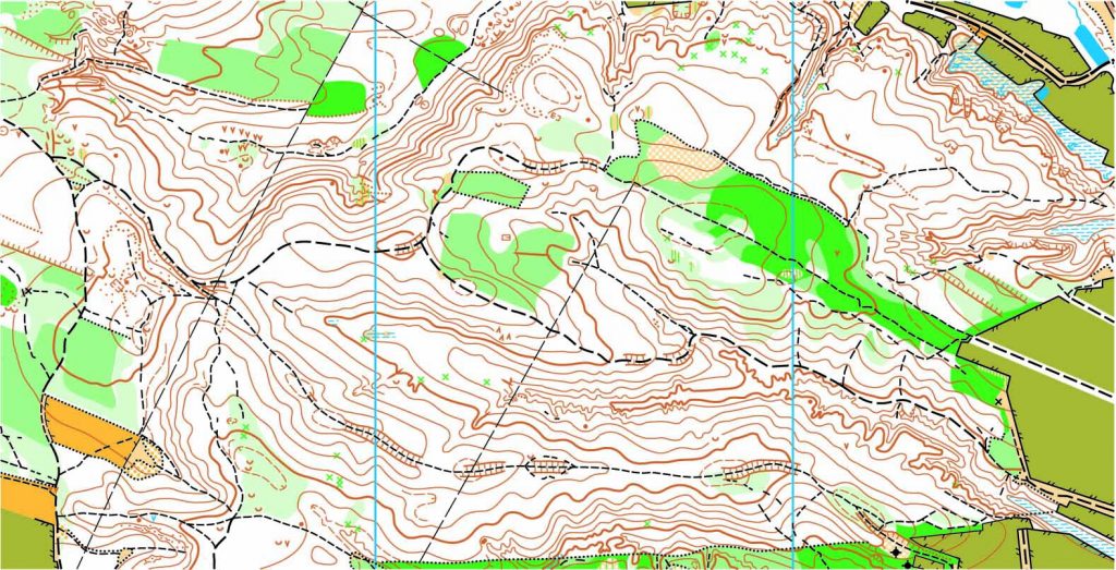
A topographic survey will show the results of a 3D world on a 2D sheet of paper. The more data the surveyor collects, the more detailed the topographic survey drawing will be. However, since there aren’t any national standards regarding topographic surveys, you’ll need to consider exactly what it is that you want to know. These are the most commonly requested:

Contour levels. The focus is on the vertical changes on the property and they are shown in a series of contours on the drawing.

Vegetation location. You can specify the location of a certain size of tree trunk or a particular type of tree (carnivorous or deciduous), vegetation lines, etc.

Streams or creeks. You can specify if you want the thread (center line), the thalweg (deepest part) or just the banks to be located and shown on the drawing.

Natural occurring structures. Peaks, valleys, hills, cliffs, etc.

Manmade structures. Items such as buildings, utility lines, streets, fences and retaining walls.

To find out more about topographic surveying, please contact us at (800) CALVADA or visit www.calvada.com.

Calvada proudly serves Corona and all surrounding areas.

Boundary vs. Topographic Surveys | Corona, CA

When you are preparing to purchase, sell or develop land, it is important to get a survey done in order to know exactly what you’re getting into. But which survey is the one that you need? Here is what you need to know about boundary and topographic surveys:

Boundary surveys. A boundary survey plots out the boundary lines of a parcel of land in order to provide specific information about where the property ends and where it begins. In addition to pinning down the precise boundary lines, many types of boundary surveys provide extra information, such as:

  • The locations of any easements (permissions to enter or cross the property, such as for utilities)
  • Encroachments, or improvements on other properties that intrude into the plot
  • Limitations, including zoning regulations

Certain boundary surveys, such as ALTA/NSPS surveys, will include even more information in accordance with ALTA and NSPS standards.

Topographic surveys. One bit of information that many boundary surveys do not provide is topographical data, or the elevations and contours of the land described in the deed, both man-made and natural. This is especially useful for those who intend to develop the land since it gives detailed information on where different features are located, including:

  • Trees
  • Slopes, hills, valleys, and other changes in elevation
  • Streams and rivers
  • Buildings
  • Streets and walkways
  • Utility poles
  • Manholes
  • Fences and walls

The elevations on the land are shown on a map as contour lines. Construction contractors, engineers, and architects use this type of map to design and plan improvements to the land.

To find out more about boundary and topographic surveys, please contact us at (800) CALVADA or visit www.calvada.com.

Calvada proudly serves Corona and all surrounding areas.