An In-Depth Look at High-definition LiDAR Surveying | Corona, CA

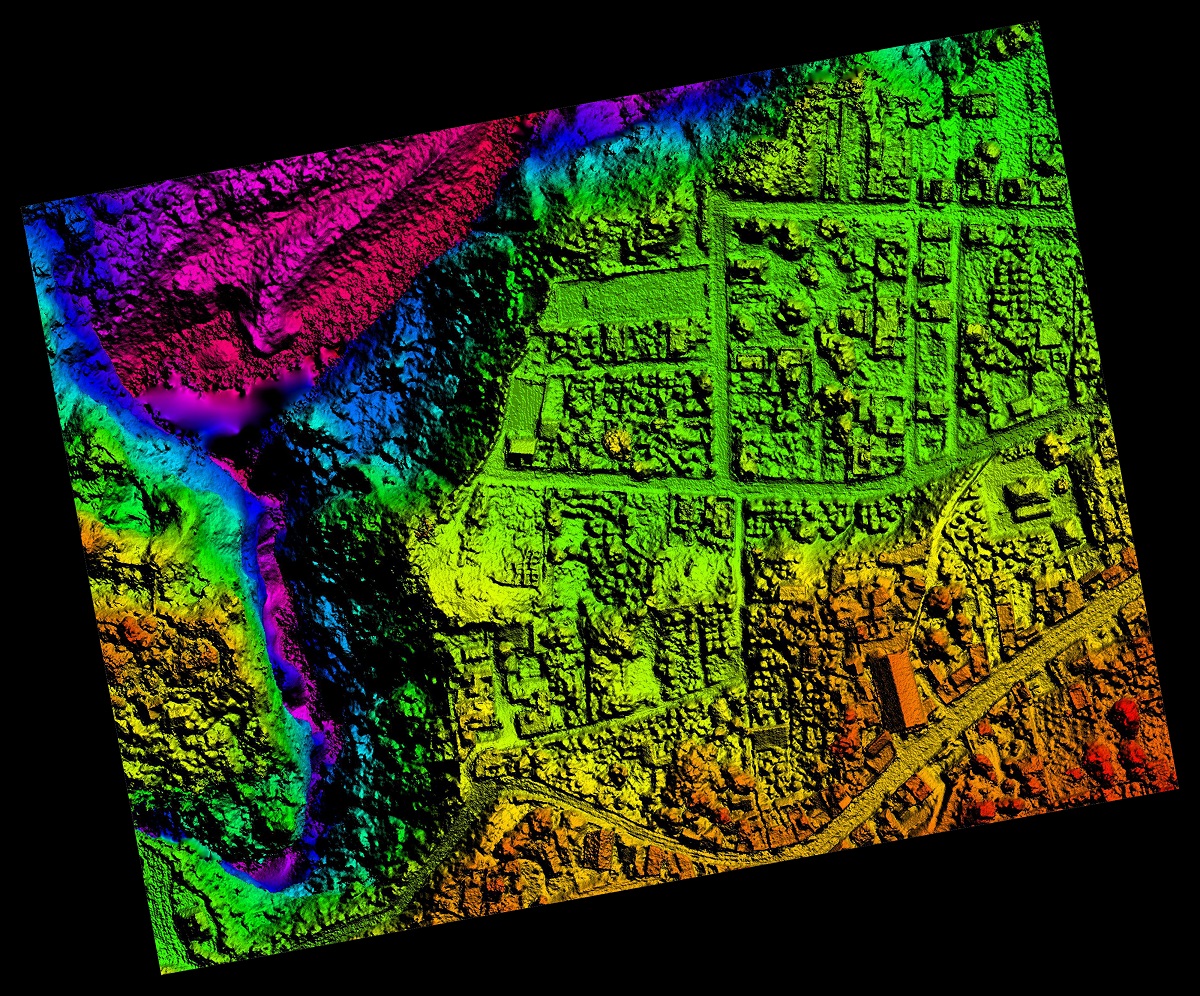
Aerial Orthorectified, Orthorectification Digital Elevation Model

High-definition surveying powered by cutting-edge technology employs a terrestrial non-intrusive approach to capture detailed and accurate as-built data. Through the use of a narrow laser beam, hundreds of thousands of closely spaced measurements can be swiftly gathered in mere minutes. The result? A richly detailed point cloud representation of the target, akin to navigating a 3D model on a computer screen.

This innovative approach not only enhances the safety of surveyors, especially in bustling environments but can also streamline the entire surveying process. At Calvada Surveying, we take pride in leveraging this state-of-the-art technology to provide unparalleled services to our clients.

What sets high-definition surveying apart is its ability to offer a comprehensive solution that meets the diverse needs of various disciplines. Whether it’s urban planning, engineering, or construction, the data generated through this method serves as a cornerstone for informed decision-making. Moreover, it fosters improved worker safety, heightened accuracy, and expedited project completion—a trifecta of benefits that significantly impacts the bottom line.

As industry leaders, we recognize the importance of staying ahead of the curve. That’s why we continually invest in the latest technological advancements to ensure our clients receive nothing but the best. Our commitment to excellence extends beyond mere satisfaction; it’s about forging lasting partnerships built on trust and reliability.

High-definition surveying and LiDAR mapping represents more than just a technological leap—they signify a fundamental shift in how we approach land surveying. With its unparalleled precision, efficiency, and safety benefits, this revolutionary method is poised to shape the future of the industry. At Calvada Surveying, we stand at the forefront of this transformation, ready to chart new territories and redefine what’s possible.

To learn more, please contact us at (800) CALVADA or visit us at www.calvada.com.

Calvada proudly serves Corona and all surrounding areas.

ALTA/NSPS Land Title Surveys: Ensuring a Smooth Real Estate Transaction | Corona, CA

Adult man the ecologist. He studies the problems of ecology arising from the removal of construction debris and soil contamination.

In the realm of real estate transactions, ensuring clear property titles and boundaries is paramount. This is where ALTA/NSPS Land Title Surveys come into play, serving as a vital tool for both buyers and lenders in evaluating the property’s worth and potential risks. ALTA, short for American Land Title Association, and NSPS, National Society of Professional Surveyors, have collaborated to create a standardized survey that provides a comprehensive overview of a property’s characteristics.

Continue reading “ALTA/NSPS Land Title Surveys: Ensuring a Smooth Real Estate Transaction | Corona, CA”

How Weather Can Affect Your Land Survey | Corona, CA

When it comes to land surveying, there are plenty of obstacles that can come into play during a typical day at work. One of these obstacles is the weather, especially during the winter season. It may seem like living in Southern California, an area that is 95% sunny day, wouldn’t be an issue, but you would be surprised – we have our own set of weather issues.

In the spring season, rain can always be an issue, and even though it isn’t a common occurrence, the sporadic nature of our rain season can make things tricky. Dressing appropriately will not only keep you dry, but also safe. And the same goes for your equipment. Because surveying is an outdoor job, everything and everyone needs to be protected. After the rain comes mud, so additional caution needs to be paid in work zones.

If you work in the winter season, there is a chance you may be working in snowy conditions. The problem is that it is likely covering up what you need to be surveying, like dangerous obstacles and essential sights such as property corners, flagging, and downed fences that you need to see to be able to complete your work.

Some may think the job is easier in this sunny climate, but the sun can often play tricks by creating shadows where you don’t want them. And let’s face it – the Santa Ana winds are a strong force to reckon with. Not only is it tough to stand in one place, but a workstation can easily become unlevel. Surveying is all about working around Mother Nature’s plans.

Remember: We may live in Southern California, the land of sunny days, but it can become quite extreme. You and your equipment have their limits.

To find out more about how weather can affect land surveys, please contact us at (800) CALVADA or visit www.calvada.com.

Calvada proudly serves Corona and all surrounding areas.

The Environmental Industry Needs Land Survey Services | Corona, CA

In this day and age, it is important that we do everything we can to create a more sustainable way of living on this planet. This being said, when designing or constructing a building, a bridge, a water pipeline or any infrastructure asset, it is important to get a land survey to find out if what you’d like to develop is actually feasible.

A land survey is generally required when designing or constructing structures such as buildings, roads, parking lots, utility corridors, or athletic fields, etc. Why? Because these surveys can give detailed account of horizontal and vertical dimensions and elevations of the structure in question, and also show above ground attributes such as utilities, access roads, parking spaces, fences, etc. More specifically, land survey deliverables for the Environmental Industry include:

  • Geotracker surveys on newly installed groundwater monitoring wells
  • Earth quantity calculations used to determine the amount of contaminated dirt to be removed
  • Topographic surveys for any environmental infrastructure design project
  • Construction staking for any environmental project that is being built from the ground up

To find out more about land surveys, please contact us at (800) CALVADA or visit www.calvada.com.

Calvada proudly serves Corona and all surrounding areas.

When Considering the Purchase of an Empty Plot of Land | Corona, CA

When purchasing a building, it is natural to get a survey done to flag any issues the edifice has prior to signing any agreement. When it comes to a plot of vacant land, it is natural to think a survey isn’t necessary as the land is empty. Unfortunately, there are things about this plot of land you may not be able to see by just walking it and only a certified land surveyor can give you those answers.

An ALTA/ASCM survey (American Land Title Association/American Congress on Surveying and Mapping) is the most comprehensive survey and is commonly recommended to the purchaser. Table A is a specific set of ALTA survey options you may want to know about, like flood zones or your neighbors. As you can see, this survey will not only show property lines, but easements, encroachments or other boundary issues that may affect your property or how the land is developed.

An easement is created when a landowner grants another party permission to use a certain portion of land for a specified purpose. This type of occurrence could be anything from a shortcut through the property to access to certain amenities. The details of these easements on the property, not the agreement itself, will be included in the survey.

An encroachment is a property improvement that partially lies on an adjacent property, without the adjacent owner’s permission. An example of this would be fencing meant to designate property lines that partially falls on the neighbor’s property in areas.

Once a survey is conducted, you can approach a purchase with more knowledge about what you are purchasing. If there are issues, they can be negotiated in order to prevent buyer’s remorse.

To find out more about purchasing land, please contact us at (800) CALVADA or visit www.calvada.com.

Calvada proudly serves Corona and all surrounding areas.