How to Add Drone Surveying Equipment to Your Business with Microdrones | Corona, CA

April 26, 2022

NY-Drone surveying equipment has become more prevalent in surveying, engineering, and construction industries. Many businesses find themselves researching UAV solutions, costs, operations, and workflows in order to keep up with the competition. They need to know what is the best way to add drone surveying equipment to their business.

To help find the solution, Microdrones is hosting a special webinar: “How to Add Drone Surveying Equipment to Your Business.” This presentation will answer questions and explain how to complement traditional surveying methods by adding drone surveying equipment to your toolbox.

The main presenter for the webinar will be Matt Rosenbalm, the Northeast US sales manager. He’ll explain how the fully integrated systems from Microdrones offer powerful aerial surveying technology to enable you to work more efficiently, accurately, safely, and profitably with the combination of our unique mdInfinity software for data processing.

“I have a strong surveying and engineering background, having been in this industry for my entire career,” said Rosenbalm. “I know how this technology can fit into your workflow on a daily basis and help grow your business.”

Drone surveying equipment improves efficiencies, saving time and money, making drones an increasingly valuable tool for a variety of projects. Register for the webinar, “How to Add Drone Surveying Equipment to Your Business,” to find out how Microdrones is providing drone solutions with everything needed to do drone LiDAR and surveying the right way, with convenient and flexible pricing options.

We look forward to showing you how to get started with everything needed to use drones for complex surveying work.

Surveying on Mars | Corona, CA

June 2, 2020 | Kellee Ireland

Here on this very website, we describe surveying as, “the measurement and mapping of our surrounding environment using mathematics, specialized technology and equipment”.

But where does that leave alien environments?

The surveyors of yesteryear were explorers of a kind, discovering foreign lands and mapping them as they went. Those documents proved invaluable records of our past geographical discoveries.

As humanity reaches out to the cosmos, surveying techniques once again are called upon to mark our place in the universe. What is surveying’s role in exploring Mars?

Surveying the next frontier

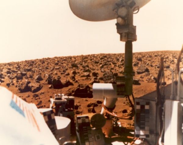
Since the 1950s, humanity has made strides to get closer to Mars. There were orbiter fly-bys that collected photographs and images in the 1960s. Then in 1976, the United States’ National Aeronautics and Space Administration (NASA) successfully sent their Viking 1 and Viking 2 orbiters to Mars, with a lander making Earth’s first touchdown on the planet’s surface. Since that day, we’ve made use of increasingly sophisticated technology in an effort to truly understand Mars.

And to understand it, first we have to map it.

Just like satellites aid modern surveyors on Earth, satellites could be used to map the surface of Mars. A particularly important step in Martian exploration was the successful launch of the Mars Global Surveyor in 1996.

The Mars Global Surveyor was designed to scan and map the entire surface of the planet from orbit. The high-resolution images it harvested showed us the highest peaks and the deepest ravines of Mars’ surface. In time, the entire planet’s surface was scanned.

The mission was to last a full decade. In this time, the Mars Global Surveyor even managed to observe the formation of new gullies, boulder tracks and craters. Meanwhile, there were ground units hitting Mars’ surface to gather additional geographic data: the Mars Exploration Rover vehicles Spirit and Opportunity spent a collective 8,000+ days roaming the planet’s surface.

One of the most recent and most exciting tools in the Mars exploration arsenal is NASA’s InSight lander.

InSight stands for Interior exploration using Seismic Investigations, Geodesy and Heat Transport. The lander is the first mission dedicated to looking deep beneath the surface of the planet, and it does this using technology similar to that which surveyors use here on Earth.

Researcher Katarina Miljkovic was one of several Australians who collaborted on InSight. Talking to Spatial Source, she explained, “InSight is different to previous Mars missions. It is not a rover or an orbiter. It is a geophysical station to be placed on the surface with passive instruments that will sense the interior structure. The aim is to understand how Mars has formed, how it differentiated and how much is it different to our planet.”

It’s thanks to NASA’s InSight lander mission that we now know that Mars experiences quakes just like Earth. We also now have a much better understanding of Mars’ interior structure and its evolution – and some of its magnetic anomolies. This is information that will be of great use in the future.

What if there was life on Mars?

But what of that future? What might traditional surveying look like on Mars if we were to ever step onto the planet’s surface?

Historically, Earth-bound surveying made use of the compass as a standard tool. With technological advances that is seldom still the case; all the same, it is worth noting the unusual magnetic activity on Mars that was noted above will impact how we might approach surveying and geodesy,

Mars has no global general magnetic field – though its pockets of magnetic rock and other magnetic anomalies would have to be accounted for by experts when they develop Martian surveying equipment.

Modern surveyors often make use of the Global Navigation Satellite System, and it is clear that something similar would be required when surveying on Mars.

What does the future hold?

It’s an intriguing prospect to think about how surveyors might adapt to entirely different planet’s environment. Certainly, it’s a much bigger leap than surveyors of the past who have just had to contend with new countries, or continents.

All we can know for certain is that technology will keep advancing, and that will impact what surveyors can achieve – both on this planet and the next.

To find out more about surveying on Mars, please contact us at (800) CALVADA or visit www.calvada.com.

Calvada proudly serves Corona and all surrounding areas.

The Teacher Land Surveyors Need Right Now | Corona, CA

Why Thomas ‘Tommy’ Boatright’s instructive videos are what land surveyors need right now.

May 24, 2021 by Emell Derra Adolphus

When Thomas “Tommy” Boatright was around 12 years old, his stepdad introduced him to land surveying and changed his life. The two of them were driving home from church when they made a stop at a local job site in their local neighborhood of Pensacola, Florida. 

“I was wearing my Sunday clothes,” Boatright remembers. “We are walking through the woods following an old wire fence, and he finds an old wooden post.” A corner. “He was so excited,” Boatright says. “Of course, at that age I didn’t care. He explained the history about the corner – but in one ear, out the other.” 

Somewhere along the way in Boatright’s teenage years, his stepdad’s enthusiasm for the land surveying profession stuck. Working part-time on a survey crew, Boatright found his niche in surveying as a “whiz kid” who could build a solution for just about any problem in the field. Now in his video column for pobonline.com, “Tommy’s Surveyor Toolbox,” Boatright is a “whiz kid” at heart with a passion for showing and telling how land surveyors can make their jobs easier in the field.

“I love to teach. I love seeing that light bulb moment in someone else’s eyes,” says Boatright. “I have produced several crew chiefs and techs.”

Among those crew chiefs and techs is William “Bill” Smith III, who says his time with Boatright helped confirm that he was on the right career path.

“I at random was just looking for a job. I thought maybe I will give this a try, and I liked it,” says Smith. “(Tommy) was my first crew chief and pretty much everything that I know I learned from him. He’s always teaching the new guys and stuff, that was a passion of his.”

With knowledge, their working relationship evolved and Smith says land surveying in Florida is better for it.

“I kind of loved it when we would work together toward the end because it was usually myself, who had made crew chief by then, Tommy and maybe another crew chief. So we had three chiefs,” he remembers. “We would just work and not have to talk about it because we all knew what needed to be done.”

“He is one of those kinds of people that don’t mind sharing his knowledge with others,” says Oscar Pittman, Boatright’s former boss at Pittman & Associates. “He’s a born teacher. He’s not shy about it. And he don’t mind helping other people. He’s always trying to think ahead, which is good. And really he’s a good guy to have around.”

Watch Tommy’s Surveyor Toolbox at POBonline.com.

To find out more about land surveying, please contact us at (800) CALVADA or visit www.calvada.com.

Calvada proudly serves Corona and all surrounding areas.

Is Technology Taking Out the Land Surveyor? | Corona, CA

Traditionally the land surveyor had a job that the typical layman couldn’t do – use fancy equipment to survey a particular piece of land and report back any data needed. It was complicated and very necessary to the function of America. It was the backbone of progress.

Today, things have changed due to the continued progression of technological advances. There is now much more sophisticated equipment developed that is now accessible to the public. People have learned to use equipment used by the land surveyor. Perhaps not for land surveying purposes, but they use it for other purposes. They can use the scanners, they can fly drones. They may not have the knowledge that land surveyors do, but with all this technology at their fingertips, is there life after technology for the land surveyor?

Curtis Sumner of the National Society of Professional Land Surveyors spoke about the future of land surveying amidst the development of COVID-19 and technology, and how we can save the future of land surveying.

To read more about his speech, click here.

To find out more about the future of land surveying, please contact us at (800) CALVADA or visit www.calvada.com.

Calvada proudly serves Corona and all surrounding areas.