Boundary vs. Topographic Surveys | Corona, CA

When you are preparing to purchase, sell or develop land, it is important to get a survey done in order to know exactly what you’re getting into. But which survey is the one that you need? Here is what you need to know about boundary and topographic surveys:

Boundary surveys. A boundary survey plots out the boundary lines of a parcel of land in order to provide specific information about where the property ends and where it begins. In addition to pinning down the precise boundary lines, many types of boundary surveys provide extra information, such as:

  • The locations of any easements (permissions to enter or cross the property, such as for utilities)
  • Encroachments, or improvements on other properties that intrude into the plot
  • Limitations, including zoning regulations

Certain boundary surveys, such as ALTA/NSPS surveys, will include even more information in accordance with ALTA and NSPS standards.

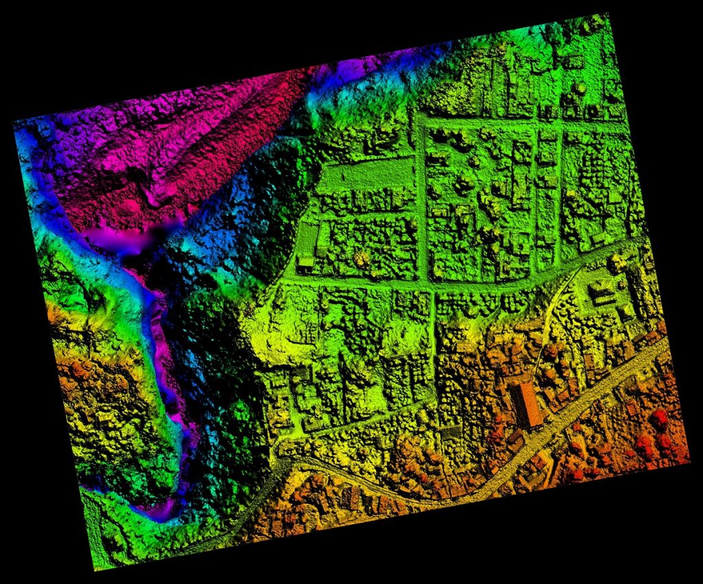
Topographic surveys. One bit of information that many boundary surveys do not provide is topographical data, or the elevations and contours of the land described in the deed, both man-made and natural. This is especially useful for those who intend to develop the land since it gives detailed information on where different features are located, including:

  • Trees
  • Slopes, hills, valleys, and other changes in elevation
  • Streams and rivers
  • Buildings
  • Streets and walkways
  • Utility poles
  • Manholes
  • Fences and walls

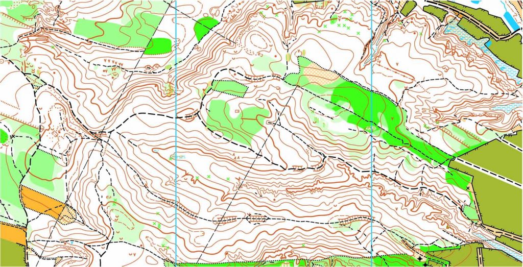
The elevations on the land are shown on a map as contour lines. Construction contractors, engineers, and architects use this type of map to design and plan improvements to the land.

To find out more about boundary and topographic surveys, please contact us at (800) CALVADA or visit www.calvada.com.

Calvada proudly serves Corona and all surrounding areas.

The Importance of Getting an ALTA Survey | Corona, CA

When you buy property, it is important to make a thorough assessment of what exactly you are purchasing. Not only to have peace of mind about what you’re buying, but because the bank and title companies will likely expect it. This is easily done by having an ALTA survey done on the plot of land. Once you fully know what you are buying, it will also be easier to build. Here are more benefits of getting an ALTA survey:

Verify a purchase. When you buy a property, you and your lender will have to make sure that the property is worth the proposed amount and is free of problems. If the survey gives a negative report, you can make decisions accordingly prior to finalizing.

Depicting easement size and location. Having adequate knowledge of easements on the property you acquire is important and an ALTA survey will reveal these details.

Locating improvements and encroachments. An ALTA survey depicts all the buildings and structures existing on a property, every property improvement and any encroachment of other people’s property.

Property access. When you buy a property, knowing the routes to your property is important. A survey will show all roads, alleys, highways, and routes that grant access, impeding structures that restrict access and other necessary easements.

Help identify and locate utilities. Whatever might be the reason for you wanting to buy a property, you will want to know if the property has the utilities you require and this can be done by showing all the utilities on the property and their various locations.

To find out more about ALTA surveys, please contact us at (800) CALVADA or visit www.calvada.com.

Calvada proudly serves Corona and all surrounding areas.

Hand Signals Used in Land Surveying | Corona, CA

There are times on a jobsite when crew members may be too far away from one another to hear each other. In these situations, Land surveyors and construction workers use hand signals to communicate over distance and noise.

Duties of a Chaining crew member

During a typical chaining operation, it is possible that many and varied duties other than the actual chaining itself are to be undertaken as part of the whole process. To prepare the field chaining party for the task ahead, we shall present some of these duties, as applicable. In some cases, these duties can be modified or tailored, contingent upon the mission, terrain features, and other conditions that may affect the speed and accuracy of the operation.

Giving hand signals and voice signals

During fieldwork, it is essential that you communicate with the other members of the survey party over considerable distances. Some-times you may be close enough to use voice communication; more often, you will use hand signals.

Avoid shouting because it is the sign of a beginner. Standard voice signals between chain-men must be used at all times to avoid misunderstanding. There are also several recommended hand signals. Those shown are recommended, but any set of signals mutually agreed upon and understood by all members of the party can also be used. It is important to face the person being signaled. Sometimes, if it is difficult for you to see the other person, it helps to hold white flagging in your hand when giving signals. When signals are given over snow-covered areas, red or orange flagging is more appropriate.

To read more about using hand signals whilst surveying, click here.

To find out more about hand signals, please contact us at (800) CALVADA or visit www.calvada.com.

Calvada proudly serves Corona and all surrounding areas.

What Is the Importance of a Topographical Survey? | Corona, CA

A topographic survey is different from other surveys by studying and measuring the surface of the land. Topographical survey measurements are carried out using both GPS or Global Positioning System and Electronic Distance Metering (EDM). The parcel elevation is shown on the map of the survey via contour lines representing the Earth’s surface’s contours and also via elevations at different spots on the map.

The topographic surveys refer to both natural and human-constructed surface characteristics such as storage walls, gas lines, wells, trees, lakes, closed spaces, buildings, utility poles, etc.

But who really needs a survey like this? Architects could use this type of survey for the construction of a 3D plot of their design. If a building site is limited by significant topographical challenges, such as steep grades, existing man-made structures or other problematic conditions, a topographical inspection is ideal in order to ensure that the design proposed will work under these conditions before construction starts.

Government agencies also use topographical surveys to produce, implement, evaluate existing infrastructure, carry out required revisions and consider environmental projects, and implement the Construction and Zoning Regulations.

And yes, these types of industries would definitely need something like this, but how about the average layman? Do these surveys come in handy? Yes. If you are planning a garden or what to do with some property you own, this survey aims primarily to gather data on the characteristics of the land and its altitude.

Topographic surveys for changes in ownership of the property or land, known also as contour surveys, must be conducted before the owner makes changes. Safety is also an extremely important reason for topographic surveys. Inaccurate, incomplete or old underground records may jeopardize your projects.

To find out more about topographical surveys, please contact us at (800) CALVADA or visit www.calvada.com.

Calvada proudly serves Corona and all surrounding areas.

Are Satellite-Based Correction Services the “Next Utility”? | Corona, CA

By Robert L. Green, PS | 06.20.2021

In the summer of 1978, I worked as a rodman/chainman for Boston Survey Consultant (now the BSC Group). My crew partnered with the engineering staff to conduct soil percolation tests for septic system design. At one point, our boss informed us he had just attended a meeting at our corporate office in Boston on the status of the GPS satellite constellation. Little was known about this technology as the first GPS satellite (NAVSTAR 1) had only been launched months earlier. He told us that within a few years you would be able to put a “magic black box” on the surface of the earth and obtain XYZ coordinates. As an 18-year-old kid, it was impossible for me to comprehend as we were in the process of locating the percolation test holes with a turn of the century K&E transit, a handheld magnifying glass to read the vernier, a Philly stadia rod for distance interpolation, and a machete for cutting line. As I reflect on this story, I realize how lucky I am to have witnessed all these measurement technology enhancements over the last four decades.

Entrepreneurs and innovators like Charlie Trimble, Javad Ashjaee and Dr. Benjamin Remondi (the father of GPS kinematic principals) capitalized on this technology. The cost for one GPS receiver when they hit the market in the late 1980s was about $100,000. Three GPS receivers, software and state-of-the-art computers were needed since most of the survey applications required GPS static survey methodology, creating a half million-dollar investment on equipment alone and resulting in only a handful of companies adopting this emerging technology. But those who did became pioneers and industry leaders.

To continue reading this article, click here.

To find out more about GPS, please contact us at (800) CALVADA or visit www.calvada.com.

Calvada proudly serves Corona and all surrounding areas.