How Weather Can Affect Your Land Survey | Corona, CA

When it comes to land surveying, there are plenty of obstacles that can come into play during a typical day at work. One of these obstacles is the weather, especially during the winter season. It may seem like living in Southern California, an area that is 95% sunny day, wouldn’t be an issue, but you would be surprised – we have our own set of weather issues.

In the spring season, rain can always be an issue, and even though it isn’t a common occurrence, the sporadic nature of our rain season can make things tricky. Dressing appropriately will not only keep you dry, but also safe. And the same goes for your equipment. Because surveying is an outdoor job, everything and everyone needs to be protected. After the rain comes mud, so additional caution needs to be paid in work zones.

If you work in the winter season, there is a chance you may be working in snowy conditions. The problem is that it is likely covering up what you need to be surveying, like dangerous obstacles and essential sights such as property corners, flagging, and downed fences that you need to see to be able to complete your work.

Some may think the job is easier in this sunny climate, but the sun can often play tricks by creating shadows where you don’t want them. And let’s face it – the Santa Ana winds are a strong force to reckon with. Not only is it tough to stand in one place, but a workstation can easily become unlevel. Surveying is all about working around Mother Nature’s plans.

Remember: We may live in Southern California, the land of sunny days, but it can become quite extreme. You and your equipment have their limits.

To find out more about how weather can affect land surveys, please contact us at (800) CALVADA or visit www.calvada.com.

Calvada proudly serves Corona and all surrounding areas.

When Considering the Purchase of an Empty Plot of Land | Corona, CA

When purchasing a building, it is natural to get a survey done to flag any issues the edifice has prior to signing any agreement. When it comes to a plot of vacant land, it is natural to think a survey isn’t necessary as the land is empty. Unfortunately, there are things about this plot of land you may not be able to see by just walking it and only a certified land surveyor can give you those answers.

An ALTA/ASCM survey (American Land Title Association/American Congress on Surveying and Mapping) is the most comprehensive survey and is commonly recommended to the purchaser. Table A is a specific set of ALTA survey options you may want to know about, like flood zones or your neighbors. As you can see, this survey will not only show property lines, but easements, encroachments or other boundary issues that may affect your property or how the land is developed.

An easement is created when a landowner grants another party permission to use a certain portion of land for a specified purpose. This type of occurrence could be anything from a shortcut through the property to access to certain amenities. The details of these easements on the property, not the agreement itself, will be included in the survey.

An encroachment is a property improvement that partially lies on an adjacent property, without the adjacent owner’s permission. An example of this would be fencing meant to designate property lines that partially falls on the neighbor’s property in areas.

Once a survey is conducted, you can approach a purchase with more knowledge about what you are purchasing. If there are issues, they can be negotiated in order to prevent buyer’s remorse.

To find out more about purchasing land, please contact us at (800) CALVADA or visit www.calvada.com.

Calvada proudly serves Corona and all surrounding areas.

There Are Benefits to Hiring Topographical Surveyors | Corona, CA

In the time of buying land or property, you or your agent should be in contact with topographical surveyors in order to educate you about the property territories and lines. From installing the fence to the land survey, surveyors will help you determine the topographic layout to make the correct decisions as a homeowner.

Topographic surveys will provide numerous benefits:

Your soil. Topographical surveyors can make you aware of your flood zone when you are buying a property. This will help you determine with your architect/engineer proper building parameters.       

Construction prep. Before starting construction, make sure you have already consulted a trained architect/engineer who will give you the green light. It’s important to check the soil to see if it is suitable for making a foundation. They will also check the underground water levels. These are all processes that an architect/engineer will go through before giving you their final opinion to begin construction.

Property value. Believe it or not, but topographical surveyors play a crucial role when purchasing or selling property and the reasons are pretty simple – if you are going to invest your hard-earned money, a topographical surveyor who will help you obtain the proper property information so an agent can help you to determine the value of the particular property.

It is fairly obvious that a topographical surveyor’s role in your land purchase/sale is a huge one, and thankfully, you can be secure in your purchases knowing that a professional is on your side. They are not only experts in their fields, but they will provide you with a plethora of benefits when you hire one. If you need a land surveyor for your property, contact Calvada Surveying, Inc.

To find out more about hiring topographical surveyors, please contact us at (800) CALVADA or visit www.calvada.com.

Calvada proudly serves Corona and all surrounding areas.

Surveying on Mars | Corona, CA

June 2, 2020 | Kellee Ireland

Here on this very website, we describe surveying as, “the measurement and mapping of our surrounding environment using mathematics, specialized technology and equipment”.

But where does that leave alien environments?

The surveyors of yesteryear were explorers of a kind, discovering foreign lands and mapping them as they went. Those documents proved invaluable records of our past geographical discoveries.

As humanity reaches out to the cosmos, surveying techniques once again are called upon to mark our place in the universe. What is surveying’s role in exploring Mars?

Surveying the next frontier

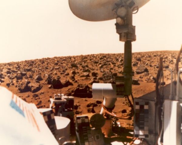
Since the 1950s, humanity has made strides to get closer to Mars. There were orbiter fly-bys that collected photographs and images in the 1960s. Then in 1976, the United States’ National Aeronautics and Space Administration (NASA) successfully sent their Viking 1 and Viking 2 orbiters to Mars, with a lander making Earth’s first touchdown on the planet’s surface. Since that day, we’ve made use of increasingly sophisticated technology in an effort to truly understand Mars.

And to understand it, first we have to map it.

Just like satellites aid modern surveyors on Earth, satellites could be used to map the surface of Mars. A particularly important step in Martian exploration was the successful launch of the Mars Global Surveyor in 1996.

The Mars Global Surveyor was designed to scan and map the entire surface of the planet from orbit. The high-resolution images it harvested showed us the highest peaks and the deepest ravines of Mars’ surface. In time, the entire planet’s surface was scanned.

The mission was to last a full decade. In this time, the Mars Global Surveyor even managed to observe the formation of new gullies, boulder tracks and craters. Meanwhile, there were ground units hitting Mars’ surface to gather additional geographic data: the Mars Exploration Rover vehicles Spirit and Opportunity spent a collective 8,000+ days roaming the planet’s surface.

One of the most recent and most exciting tools in the Mars exploration arsenal is NASA’s InSight lander.

InSight stands for Interior exploration using Seismic Investigations, Geodesy and Heat Transport. The lander is the first mission dedicated to looking deep beneath the surface of the planet, and it does this using technology similar to that which surveyors use here on Earth.

Researcher Katarina Miljkovic was one of several Australians who collaborted on InSight. Talking to Spatial Source, she explained, “InSight is different to previous Mars missions. It is not a rover or an orbiter. It is a geophysical station to be placed on the surface with passive instruments that will sense the interior structure. The aim is to understand how Mars has formed, how it differentiated and how much is it different to our planet.”

It’s thanks to NASA’s InSight lander mission that we now know that Mars experiences quakes just like Earth. We also now have a much better understanding of Mars’ interior structure and its evolution – and some of its magnetic anomolies. This is information that will be of great use in the future.

What if there was life on Mars?

But what of that future? What might traditional surveying look like on Mars if we were to ever step onto the planet’s surface?

Historically, Earth-bound surveying made use of the compass as a standard tool. With technological advances that is seldom still the case; all the same, it is worth noting the unusual magnetic activity on Mars that was noted above will impact how we might approach surveying and geodesy,

Mars has no global general magnetic field – though its pockets of magnetic rock and other magnetic anomalies would have to be accounted for by experts when they develop Martian surveying equipment.

Modern surveyors often make use of the Global Navigation Satellite System, and it is clear that something similar would be required when surveying on Mars.

What does the future hold?

It’s an intriguing prospect to think about how surveyors might adapt to entirely different planet’s environment. Certainly, it’s a much bigger leap than surveyors of the past who have just had to contend with new countries, or continents.

All we can know for certain is that technology will keep advancing, and that will impact what surveyors can achieve – both on this planet and the next.

To find out more about surveying on Mars, please contact us at (800) CALVADA or visit www.calvada.com.

Calvada proudly serves Corona and all surrounding areas.
The Importance of Getting an ALTA Survey | Corona, CA

When you buy property, it is important to make a thorough assessment of what exactly you are purchasing. Not only to have peace of mind about what you’re buying, but because the bank and title companies will likely expect it. This is easily done by having an ALTA survey done on the plot of land. Once you fully know what you are buying, it will also be easier to build. Here are more benefits of getting an ALTA survey:

Verify a purchase. When you buy a property, you and your lender will have to make sure that the property is worth the proposed amount and is free of problems. If the survey gives a negative report, you can make decisions accordingly prior to finalizing.

Depicting easement size and location. Having adequate knowledge of easements on the property you acquire is important and an ALTA survey will reveal these details.

Locating improvements and encroachments. An ALTA survey depicts all the buildings and structures existing on a property, every property improvement and any encroachment of other people’s property.

Property access. When you buy a property, knowing the routes to your property is important. A survey will show all roads, alleys, highways, and routes that grant access, impeding structures that restrict access and other necessary easements.

Help identify and locate utilities. Whatever might be the reason for you wanting to buy a property, you will want to know if the property has the utilities you require and this can be done by showing all the utilities on the property and their various locations.

To find out more about ALTA surveys, please contact us at (800) CALVADA or visit www.calvada.com.

Calvada proudly serves Corona and all surrounding areas.